“Rivers run into the sea, but the sea is never full. Then the water returns again to the rivers and flows out again to the sea.”
Ecclesiastes 1:7 (NLT)
“In the small town of Hannibal, Missouri, when I was a boy, everybody was poor, but didn’t know it; and everybody was comfortable and did know it.”
Mark Twain (1835–1910)
Tanjung Selor
1.0 Physical
Geography: Tanjung Selor, the capital of North Kalimantan Province, spans a city area of 1,277 km², a size comparable to Portland City in the USA.
Population Dynamics: As of 2020, Tanjung Selor’s population stood at 56,569, with projections estimating a significant rise to 1.2 million by the year 2050.
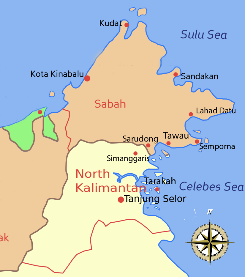
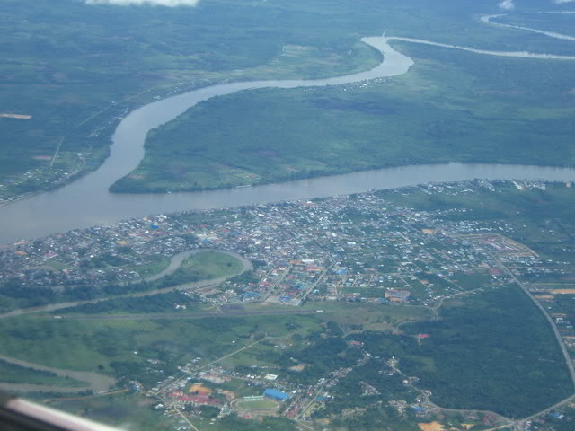
Location: Nestled in the northern region of Kalimantan, Tanjung Selor enjoys proximity to the delta region, providing direct access to the Celebes Sea. The town is strategically positioned along the lively Kayan River.
Distance from Tanjung Selor to other capital and major cities in Borneo:
| City | km |
| Balikpapan | 461 |
| Bandar Sri Begawan | 354 |
| Banjarmasin | 751 |
| Kuching | 794 |
| Pontianak | 948 |
| Samarinda | 374 |
| Tarakan | 57 |
| Tawau | 166 |
Tropical Climate: Tanjung Selor, positioned at 2.8° north of the equator, experiences a tropical climate characterized by an annual rainfall of 2,716 mm and an average temperature of 26.9 °C. Notably, North Kalimantan shares its borders with Sabah, Sarawak, and East Kalimantan.
Key Attributes:
- Gateway to Kayan Mentarang National Park: Tanjung Selor serves as the entrance to the expansive Kayan Mentarang National Park, a significant conservation effort spanning 13,600 square km in Southeast Asia.
- Heart of Borneo Project: North Kalimantan is an integral part of the Heart of Borneo initiative, backed by the World Wide Fund. This project boasts a vast forest reserve covering 220,000 km², marking it as the largest rainforest conservation in Asia.
- Rich Wildlife: The region is home to diverse wildlife, including pangolins, proboscis monkeys, gibbons, leopards, hornbills, and occasional sightings of elephants and rhinoceros.
- Strategic Shipping Route: North Kalimantan plays a crucial role in Indonesia’s major shipping route to Asia Pacific countries.
- Abundant Forest Cover: Encompassing an impressive 6,440,254 hectares, forests cover over 90% of the total area of North Kalimantan.
Unique Attributes:
- Extensive Borneo Forest Reserve: Tanjung Selor boasts a large forest reserve in Borneo Island. The region is sparsely populated, offering vast expanses of land along a crucial marine route to the Asia Pacific market.
- Strategic Location near Tarakan: Tanjung Selor’s strategic location, in proximity to Tarakan, an important port city, positions it advantageously for trade in petroleum, fisheries, and forest products.
2.0 History
Historical Background: The historical narrative of North Kalimantan Province is intertwined with the reign of the Sultanate of Bulungan. This influential sultanate held sway not only over the province but also extended its influence to encompass the eastern region and Tawau in Malaysia.
| Event | Year |
| Sultanate of Bulungan | 1731 |
| Part of Dutch Indies | 1893 |
| Dutch Administration | 1930 |
| Sultanate Abolished | 1959 |
| Tanjong Selor in East Kaltara | Before 2012 |
| Tanjong Selor, Capital of North Kaltara | After 2012 |
Unique Attributes:
- Former Bulungan Sultanate Legacy: The remnants of the historical Bulungan Sultanate linger, contributing to the region’s unique cultural and historical tapestry.
- Dutch Administration Influence: The imprint of Dutch administration is evident, adding a historical layer to the area. This influence may manifest in various aspects, from architecture to governance structures.
- Abundant Natural Forest: North Kalimantan boasts expansive and rich natural forests, creating a distinctive landscape. This ecological wealth not only contributes to the region’s biodiversity but also plays a role in its economic and environmental character.
3.0 Economy
Tanjung Selor’s economy, aligned with North Kalimantan, centres on agriculture, forestry, fishery, and mining. Seeking foreign investment, the region targets key industries like palm oil and fisheries.
- Tourism:
- Untapped natural wonders like Amal Beach and Kayan River await development.
- Strategic investments needed for tourism infrastructure.
- Industry:
- Gateway to North Kalimantan’s mining, agriculture, and processing sectors.
- Key industrial estates: Delma Mandiri, Tanah Kuning, Mangkupadi.
- Connectivity:
- Tanjung Harapan Airport: Expanding to accommodate growing domestic travel.
- Major seaports: Malundung, Nunukan, Tarakan, Pesawan, Tunon Taka, Sebatik.
- Resources:
- Oil & Gas: Tarakan basin holds reserves; Pertamina active in Maratua.
- Agriculture:
- Focus on rice, cassava, and tropical fruits.
Unique Attributes:
- Abundant natural resources offer development opportunities.
- Agriculture sector holds growth potential.
4.0 Language
Linguistic Diversity:
In Tanjung Selor, Malay, Tidung, Bugis, and Dayak stand out as the predominant languages.
Unique Feature:
- The prevalence of the Malay language serves as a unifying force, facilitating effective communication across government, business, and the local community.
5.0 Investment Opportunities
5.1 New Migration:
- Population set to soar from 52,000 to 1.2 million in 30 years, driven by expatriates and labor force.
- Job opportunities in mining, agriculture, food processing, and SEZ to accommodate new migrants.
5.2 Airport:
- A new international airport to handle the surge in tourism and business travel.
- Integral to the Borneo airport hub, connecting domestic, regional, and international flights.
5.3 Economic Corridors:
- BIMP-EAGA planning the East Borneo Economic Corridor.
- Highway project linking the new capital city, four Kalimantan provinces, Sabah, and Tanjung Selor.
5.4 Tourism:
- Need for a comprehensive tourism strategy for eco-tourism and wildlife attractions.
- Unexplored natural destinations like river cruises, rainforests, and undeveloped beaches.
5.5 Infrastructure:
- New interstate and international highways linking Kalimantan provinces and Sabah/Sarawak.
- Trans-Borneo rail network for goods, services, and people.
- Development of water treatment plants for the booming population.
- Planned Kayan Hydropower Plants to meet energy demands.
5.6 Agriculture:
- Focus on food crops for domestic use and regional exports.
- Investment in horticulture, livestock, and agriculture estates, including palm oil and rubber plantations.
5.7 Special Economic Zones (SEZ):
- Downstream food processing industries for local and regional markets.
- Agriculture downstream industry, including palm oil, cocoa, coffee, and pepper processing.
- Establishment of a Borneo Cold Chain hub leveraging strategic coastal location.
- Oil and gas exploration in Bulungan, Tana Tidung, and Nunukan.
- Tourism potential with natural destinations and industrial investments.
5.8 Cross Border Trading:
- Collaboration between North Kalimantan, Sabah, and Sarawak.
- Focus on agriculture, food processing, cold storage, medical services, and tourism.
- Infrastructure development for seamless connectivity, including highways and bridges.
- Exchange of labour, with Sabah’s oil palm plantations requiring Indonesian farmworkers.
- Trade opportunities at tri-party border for downstream manufacturing and cross-border trade.
- Investment from local and foreign sectors, especially in natural resources, minerals, agriculture, and aquaculture industries.
North Kalimantan share common border with Sarawak and Sabah
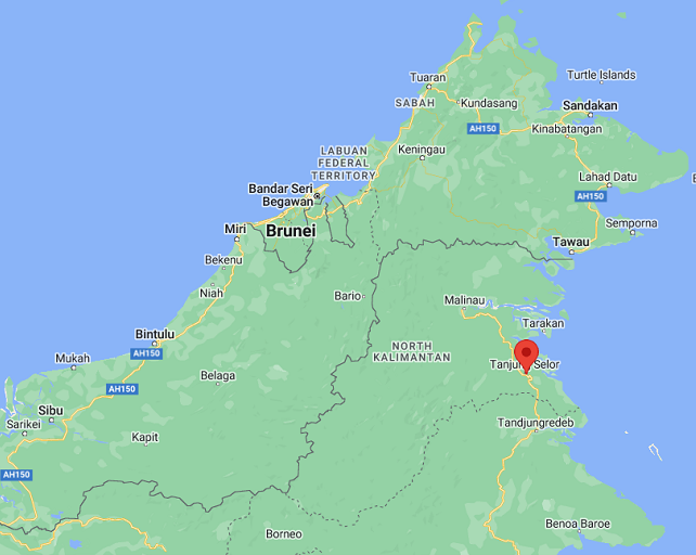
Tanjung Selor (North Kalimantan) and Tawau (Sabah)